Showing posts with label weather. Show all posts

Friday, 9 August 2019

BREAKING: Residents Evacuated as Roof Ripped from Stockton Nursing Home

BY MADELAINE MCNEILL

Emergency services are on the scene at Stockton where the roof of a nursing home has been ripped off by severe winds.

NSW Ambulance have evacuated 30 residents from the centre on Fullerton Street and ambulance crews are on hand to assess them after high winds tore a hole in the structure shortly after 10am.

300 square metres of the roof has been ripped from the structure and Fire and Rescue are assessing whether it can be strapped down.

Three fire trucks including a ladder platform and a rescue truck have responded to the incident and police are also at the scene.

Police, SES and Fire and Rescue are warning Hunter residents to stay safe as a damaging cold front continues to roll in across the state.

All ferry services on the Stockton-Newcastle line have also been suspended due to the wild weather.


Tuesday, 6 June 2017

Batten down the hatches!

BY JESSICA ROUSE

It's about to get a whole lot colder in Newcastle but if you're in the Barrington Tops it's about to get freezing. 

Snow is predicted to fall on the Barrington Tops with an east coast low funnelling through the Hunter tonight bringing with it strong seas, cold wind and rain for most of the week.

Wind speeds will pick up tonight with cold temperatures, shower activity on the coastal fringe with some of the moisture landing on the high peaks of the Barrington Tops, big seas, and very cold wind chill factors which will combine to make the perfect conditions for snow on the high peaks.

"Well it looks like the east coast low will form, its going to hit us quite hard overnight and throughout tomorrow and then it looks like it's going to track north and its going to hug the northern NSW coast and that means we're going to be on the southern side of it and whenever you're on the southern side of a low that drives in those strong winds, the showers and the clouds," said NBN weather presenter Gavin Morris.

The first dusting of snow is being predicted for the Barrington Tops by tomorrow morning.

"Places along the coastal fringe exposed to those high wind areas, make sure you tie down everything including trampolines! Everybody forgets about them but they're usually the first to get lifted out of the backyard, check boats and moorings and all those sorts of things. Go and give them a check today to make sure they're all secure," said Gavin Morris.

Image journaltimes.com

Friday, 19 May 2017

Rain, rain go away, come again another day

BY JESSICA ROUSE

The Hunter is in for a change in weather this weekend with northeasterly winds forecast for this afternoon and a wet, wet weekend.

A slow moving rain band is making its way across the state and will bring with it a consistent dumping of rain which will be around for most of the weekend. It's not expected there'll be hundreds of millimetres of rain, but there'll be plenty of it and possibly thunderstorms.

"There's a big rain band moving in across the western part of the state and that is going to be moving through tonight and it's fairly slow moving so it's going to take most of Friday night into Saturday and probably affect the majority of Saturday as well so it's widespread in most locations right throughout the greater Hunter are going to see rain from this," said NBN Weather presenter Gavin Morris.

It'll be colder too, with a lack of sunshine, temperatures will fall into the low teens overnight and stay quite cool into next week.

"We've got a real lack of heating due to no sunshine. It's a big blanket of cloud. The winds are out of the north east and they're going to be getting moderately strong but generally, when you've got them out of the north it's not as cold, it's just due to the lack of heating as that rain band moves through," said Gavin Morris.

The rain couldn't have picked a worse weekend to come, with plenty of outdoor events planned for the weekend including the annual Lovedale Long Lunch in the Hunter Valley.

"There's a lot of outdoor activites that are on this weekend so if you've got one just be prepared for that rain. It's not one of those huge east coast lows and its not a massive weather event but it is going to be wet so the big tip is just be prepared for that wet weather," said Gavin Morris.


Thursday, 27 April 2017

Steer clear of the Hunter's beaches

BY IAN CROUCH and JESSICA ROUSE

Hunter residents are being urged to steer clear of the beach over the next couple of days with waves expected to reach up to five metres today and tomorrow.

It's prompted warnings from Surf Lifesaving NSW to all beachgoers and rock fishermen around the region to stay away from all our beaches.

It comes as the Hunter prepares for the coldest day of the year so far, with temperatures only set to reach 18 degrees in some areas today - four degrees below average.


Friday, 30 September 2016

Hunter Could have Blackouts Like SA

BY GARY-JON LYSAGHT

The Hunter could see blackouts similar to those in South Australia because of the State and Federal Governments axing of more than 2600 power workers, says the Electrical Trades Union.

Since 2012, the Government has gradually cut back workers across the State and in various companies.

Over the past four years, almost a quarter of all electrical workers have lost their jobs, including 1400 from Ausgrid and 800 from Essential Energy.

ETU Assistant Secretary Dave McKinley says the next natural disaster NSW faces could plunge it into darkness, much like South Australia this week.

"What has occurred in South Australia in the past 24 hours could easily happen in NSW," he said.

"The ability to restore power for consumers is dependent on having skilled workers available.

One of many fallen SA power lines. [Image: Tom Fedorowytsch]
"This loss of skilled workers will have a devastating effect on response time and the speed which power can be reconnected."

All of South Australia lost power on Wednesday night as wild winds and rain lashed the state, causing its wind turbines to switch off.

Power lines across the state also collapsed, which led to the extreme blackout.

The Hunter has also had wild winds, with parts of Dungog and Maitland submerged in water for days following last April's super storm that lashed the region.

McKinley is calling on Ausgrid and

other other providers to be prepared for the next weather event.
"We are urging them to take a good hard look at the resources they have available moving forward so they can ensure they have the skilled workers and specialist equipment needed to respond to similar events when they occur in NSW," he said.

[Image courtesy of ABC].


Tuesday, 12 July 2016

Hold onto your hats Newcastle, the winds are coming!

BY JESSICA ROUSE

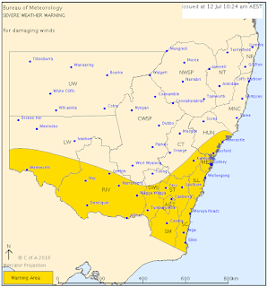
A strong cold front is expected to sweep across NSW this afternoon after a relatively mild couple of days in Newcastle.

The Bureau of Meteorology have forecast northwesterly winds which are set to increase ahead of the front, before leaving a cold and gusty westerly in its wake.

Meteorologist Christopher Webb from the Williamtown Weather Office, says temperatures are expected to reach a maximum of 20 degrees today, before the cooler conditions hit.

"Much colder conditions to come for tomorrow, Thursday and Friday and also the winds will strengthen this afternoon ahead of that front and may reach gale force this evening and overnight and the front goes through." 


Thursday, 28 January 2016

Hunter Breaks Rain Record

The Hunter is expected to have more rainfall for the rest of the week, following sunny skies for the Australia Day holiday.

Rainfall is expected to varied, with some parts expected to receive up to 60 millimeters of rainfall, while others may receive as low as 5.

Chris Webb from the Williamtown Weather Office says the showers will effect everyone.

"For the entire Hunter district tomorrow and Saturday, they'll be some showers and thunderstorms in the afternoon."

"At this range it's not possible to know where we'll get it, but we're confident there will be some about."

The upcoming rainfall will push this January into the wettest one in memory.

"We've got an old record of 404mm, 1895 it dates back to" says Mark Wilgard, Observations Officer at Williamtown Weather Office.

"As of yesterday, 9am we had 402.8mm, but since then we've got the 1.2mm."

"So the record's been equaled."

This weekends rain is being blamed on a low pressure trough which is moving itself across the Hunter.

"We think with the trough nearby there will be some showers and thunderstorms this evening" said Mr Webb.

"That trough will probably move across the Hunter on Saturday, causing more showers and thunderstorms."

The poor weather is expected to move on by Sunday.


Friday, 28 February 2014

SES Weather

The State Emergency Service is being kept on its toes today with significant rainfall across the Hunter.

A minor flood warning has been issued by the Weather Bureau for Lake Macquarie, with more than 200mm of rain recorded at Cooranbong and Blacksmiths.

There are reports of flash flooding around Swansea and Dora Creek.

The SES has received 63 calls for assistance, mainly related to localised flooding.

Anyone requiring emergency assistance may ring 132 500.